The capital of North Korea is Pyung-yang. Pyung-yang is a city under the direct control of the central government. The area of Pyung-yang is 2,629㎢ and the number of people is 3,159,000(in 2009).
Pyung-yang is the largest city in North korea and the center of politics, administration, economy, and culture.
It was the seat of provincial government when Korea was liberated, and in 1946 Pyung-yang was promoted to metropolitan city.
The current administrative districts are Joong. Pyung-chun. Bo-tong-gang. Dae-dong-gang. Man-gyeong-dae, Yong-sung, etc. It is divided into Gang-nam, Joong-hwa, Sang-won, Gang-dong.
It is the center of Pyung-yang industrial zone which is the biggest one of North Korea. There are heavy industries such as, mechanic, fuel-energy, and construction and light industries like clothing, shoes, and food.
Pyng-yang has a
Also, Pyung-yang is central area of transportation. It is a starting point of train(rail road), Express way, and is a bus terminal. There is a international rail road to Moscow and Beijing and Soon-ahn air port in Soon-ahn district. The subway system is 34km, including Cheon-ri-ma line, Hyuk-sin line, Man-kyung-dae line.
The climate is 10.4'C, a year average, 986mm, a year average.( National Weather Servce, 1996)
Here comes some pictures of Pyung-yang.
Pyung-yang city
The flag of the Soviet Union.
The tower of Juche idea(주체사상탑)
"JOE-SUN KOREA hotel" in pyung-yang
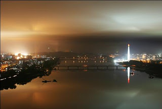
The nightscape of Pyung-yang
Satellite picture of North Korea
China, South Korea, and Japan are bright, but North Korea is black except for Pyung-yang(little light).


